Place :Ponmudi
Location: About 61 km from Thiruvananthapuram city,south Kerala.
Altitude: 915m above sea level.
Located within a short driving distance of Thiruvananthapuram, Ponmudi is an enchanting hill resort with narrow winding pathways and cool, green environs. Along with a beautiful array of mountain flowers, exotic butterflies and small rivulets, Ponmudi offers excellent opportunities for trekking. With its tea estates and mist covered valleys Ponmudi is a fast developing hill resort with cottages and dormitory accommodation facilities.
Getting there:
Nearest railway station : Thiruvananthapuram central, about 61 km
Nearest airport : Thiruvananthapuram International Airport about 67 km
Tourist Attractions in Ponmudi
Agasthyarkoodam :
This 2000 feet high peak is famous for its wilderness, and can be accessed only with permission from the Forest Department. Meenmutti waterfall is an eminent attraction in the range.
Agasthyakoodam is the second highest peak in Kerala, at a height of 1890mts above sea level and is a part of the Sahyadri range of mountains.It is 60 Kms North East of Trivandrum.The mountain is revered by both Buddhists and Hindus, as it is believed to be the abode of the Bodhisattva Avalokitesvara as well as of the sage Agastya, a disciple of Shiva
The forests of Agasthyakoodam are rich in rare medicinal herbs and plant, and hued orchids. In 1992, an area covering around 23 sq kms was established as Agasthya Vanam Biological Park. The intention was to restore the degraded forests and to use it for educational purpose. The season from December to April is advocated for trekking and is a distance of 28 kms to the top. It takes approximately two days and trekking is permitted only between December and April.
Golden Valley : - A small yet picturesque viewpoint, adorned by well-rounded pebbles and lush green trees, this is an access-point to the River Kallar.
Devikulam
Located 16 kms from Munnar, this gorgeous hill station symbolises nature in her pristine glory. The crisp and cool mountain air heavily laden with the fragrance of wild flowers and rare herbs is any nature lover's paradise. hill station is located at a height of 1800 meters above sea level .
The Sita Devi Lake offers rejuvenating springs of mineral water and is also a favourite picnic spot among tourists. Besides the expansive tea plantations, a spice garden run by the district tourism promotion council nurtures a wide variety of spices.
The main attraction of Devikulam is the legendary Sita Devi Lake. According to legend, Sita, the holy consort of Lord Rama, came down to take a bath in the lake and ever since, the place came to be known as 'Devikulam' (the Lake of Goddess). The scenic lake is among the most favorite picnic spots in Kerala. The main characteristics of the lake are its fountain springs, which spout rejuvenating mineral water. You can also enjoy fishing in the lake and trout can be your prized catch.
Places Where You Can Visit
Munnar
A hill station [a high station] of spectacular views, where three mountain streams confluence. Munnar waterway offers boating facility. Anamudi the highest peak in South India [2695m] is an ideal spot for trekking. Among the exotic flora found in the forests and grasslands is the Nelelakurinji, the flower that bathes the hills in blue every twelve years will bloom next 2006 AD. Eravikulam National park is another attraction. Munnar is 130 km east of Kochi and 70 km north of Kumily. Chinnar Wildlife
From Munnar- Uthummal Petah route; 94 sq Km area the Chinar wild life sanctuary situated. Elephants, buffalo, tiger, leopard can be seen at this sanctuary. Kumily
Kumily is the junction town straddling the Kerala Tamilnadu border just north of park boundary. It 's a busy place full of spice shops, located about 4 Km from Thekkady. The boat trip in the lake are the standard way of seeing the Sanctuary. The standard two hour boat trips available. Jungle walks can also be interesting. Mangalam Devi Temple
This temple is just a jumple of ruins and the views are magnificent. The festival of this temple falls on the day of 'Chaitra Pournami'. Marayur
Place of the Sandal Forest. Very old 'Sannyasi Caves also can be seen here. Famous for hand woven 'Pattu Sarees'. ' Marayur Sarkara' [Molasses] also famous. Moolamattom
Kerala's biggest underground Electricity generating project. Idukki
The first dam in India at River Periyar. Wild life Sanctuary is also at Idukki. Plenty of elephants can be found here. Rajamala
It is the part of the National Park,14 km from Munnar where Tahir Goats can be seen.
About the Weather
You may enjoy the cool mountain air throughout the year,here at Devikulam.
Accommodations Available at Devikulam
The Govt. owned Guest House at Devikulam ensures comfortable stay in the midst of the misty slopes of the Western Ghats.
How to Reach Devikualam
Devikulam can be reached from both Kottayam and Kochi. The distance from Kochi is 149 km (4 hr drive) and that from Kottayam is 132 km (4 ½ hr drive).
Travel Tips
The climate is mild with a slight chill after nightfall so carry cotton shawls and jackets
If you want to fish in the lake seek permission from Tata Tea
Enjoy treks along the hill slopes away from the metal road.
Peerumedu
Peerumedu is a Village in Azhutha Taluk in Idukki District in Kerala State . Peerumedu is located 33.6 km distance from its District Main City Idukki - Kanjikuzhy . It is located 121 km distance from its State Main City Thiruvananthapuram .Other villages in Azhutha Taluk are Elappara , Kokkayar , Kumaly , Peruvanthanam , Azhutha , Vandiperiyar
IT is a small hill station, snuggled at an altitude of 914 m above sea level, on way to Thekkady. The famous plantation town takes its name from Peer Mohammad, a Sufi saint and close associate of the erstwhile royal family of Travancore.
Clouds drop gently on the peaks that flank the verdant slopes of Peerumedu. Rich with mile upon mile of plantations falling away in precise steps.
Coffee, tea, pepper, cardamom and rubber flourish in what is the most fertile part of the Western Ghats. Broken only by spectacular waterfalls in the distance and wide open grasslands in places.
On a fairly warm day, the mercury reads between five and ten degrees celsius. Little wonder then, that the former Rajas of Travancore sought this tiny hill station out as their summer resort.
Places of Interests of Peerumedu
Kuttikanan, Thrissanku Hills are some of the places of interests in Peerumedu. These can mesmerise the tourists` mind to the fullest.
Thrissanku Hills: Lying almost four km from Peerumedu and ½ a km from Kuttikanam, this hill tract, nestled within undulating hills, is spectacular to look at. Gentle breeze offers a stroke of affection to the people. Taking stroll for miles one can see the spectacle of sun setting and rising in the open horizon. It is an experience which everybody can cherish for long.
Peeru Hills, another tourist attraction is only four km away from the place. It is a trekkers delight. People also regard it ideal for picnicking. Mausoleum of the Sufi saint Peer Mohammad, majestic summer palace of the regal family and the magnificent Diwan residence lies close by. These are all worth visiting.
Kuttikanam
Kuttikanam is an ideal place for all people who have a nose for adventure tourism. From Peerumedu one needs to trek only a short distance of 3 km to reach the destination.
Vagamon
Vagamon is another attraction of tourists. It is located at a distance of only twenty-five km from Peerumedu. Grassy hillocks, velvet-textured fields make the place a ideal retreat for tourists. Cool breeze blows over the mountain. It enmeshes a peculiar religious fervour within the western tradition and culture and becomes a refuge of calmness. Special attractions are Thangal hills, Mudugan Hill and Kurisumala which are standing symbol of religious spirits. There is a dairy farm, which is managed by the Kurisumala monastics. Tourists visit this place also.
Other places like Kalthotti, Karandakapara Hills, Grampi (Paruthupara) and Memala are ideal destination for trekkers. Tourists also pay visit to the tea, coffee, cardamom and rubber plantations.
Touring places like Meloram, Nallathanni, Panchalimedu, Valanjamkanam waterfalls etc. would be quite memorable.
Sahyadri Ayurvedic Centre is a landmark. This famous Ayurvedic Hospital is supervised by the Peerumedu Development Society in Pallikunnu. It specializes in remedial and rejuvenating treatment packages. It offers well-appointed treatment and accommodation facilities comprising a unit for producing ayurvedic medicines. There is also a well-maintained raw drugs museum which houses more than two hundred types of rarified and rare herbs. Inside this hospital there is a beautiful garden covering a total area of more than thirty-five acres of land. Oven four hundred herbs rich in medicinal values are grown here.
Accommodation in Peerumedu The hill station of Peerumedu is thronged with a handful of hotels and lodges, offering fabulous services to their lodgers. In other words due to hi-class accommodation services the stay of lodgers in Peerumedu, Kerala have become even more thrilling. Accommodation ranges from lavish hotels to low costs ones. The Royal Summer Residence now has been transformed into a Government Guest House. Offering comfortable accommodation, it is supervised by the Department of Tourism.
Hotel Himarani International, Idukki-685531, Thekkady, Kerala, India, is a famous hotel here.
How To Get There - Peerumedu
Reaching Peerumedu is quite easy. A person has to travel two hours to reach the place. Regular buses ply in the surrounding cities like Kumily and Kottayam. Numerous roadways have established connectivity of Peerumedu with other places of Kerala. These well maintained roads also link with cities of adjoining areas like Tamil Nadu.
Peerumedu is 85 kms east to Kottayam (travel time: 2 hours), on the way to Thekkady. There are frequent bus services from nearby cities of Kumily and Kottayam.
By Rail:The closest railway station of Peerumedu is Kottayam, which lies almost eighty-five km from this picturesque hill station of Kerala.
General Information - Peerumedu
Location
85 Kms East Of Kottayam.
Altitude
914 m Above Sea Level.
Main Attraction
Kuttikanan, Thrissanku Hills.
Languages
Malayalam, Hindi, English.
VAGAMON
It is a very ideal tourist spot surrounded by the greenery of tea gardens, beautiful meadows, deep puzzling valleys and dales. The enchanting hill station dotted with tea gardens will soon be one of India's foremost eco-tourism projects.
All the trekking enthusiasts will enjoy climbing this 1100 metres tall hill. This tourist place also has to offer Thangal Para, the Indo-Swiss Project and Kurisumala Ashram. Welcome to a land which would make you come back again and again. So that you could rejuvenate yourself and cherish memories of this enchantingly beautiful land.
If you have not been to Vagamon you have not seen God's Own Country. Vagamon provides unlimited holidaying fantasies round the year, except with the season being slightly off during the monsoons. Vagamon, the final word in your holiday options, provides unlimited holidaying fantasies round the year, except with the season being slightly off during the monsoons. A land, which would make a person come back again and again, so that you could rejuvenate yourself and cherish memories of this enchantingly beautiful land.
Water fall
This is essentially a lake and it's catchment area, with grassy hillocks stretching into the forest on one side and ending at the cliff on the other. This large tract of land has a small stream originating at the lake and going through.
Water falls and the ravine. The steep hill tract which provides access to the water fall area is along the ridge and there can be many pavilions along that to enjoy rain, wind, and the infinite view of the hillscapes. There can also be performance podiums with the mountainous landscape as the background.
The stream goes along the ravine and can be developed as a trekking path as it is a rugged route, with rocks and rough undulations. A small facility like a coffee bar and the like would add the richness of the place with more participation. A reservoir up stream would ensure the presence of enough amount of water even during dry season. A stepped path leading to the water fall itself is a thing of interest.
Rocky out crop
The steep rocky hill tract is almost mountainous in character. The cliff and ravine topography area is ideal for adventure activities that would attract people who like gliding, rope climbing, jumping and the like. There can be viewing pavilions too, as gufas in the vertical surface of the hill which would attract people for staying inside. This can be carved out of the rocks and would provide an adventurous stay.
Forest
Around 100 acres of forest area could be developed as a holistic health care center with Ayurveda as the theme. Providing treatment, health care facility, rejuvenation centers, yoga and meditation center, naturopathy clinics, herbal garden etc. emphasizing the theme of living with nature and exploring the aeons old way of life. Tree walks, medicines preparation areas, etc. all designed to a character of ashrams.
Grassy planes
Features:
1. Eucalyptus plantation
2. Road side slope
3. Grassy hills
4. School hill
5. Cliff side
The area is rather featureless compared to other parts of the site, with grassy, slowly rolling plains. It has a direct access from the road and slopes down from there ending at the cliff. At present there are plantations of eucalyptus, tea and some agricultural crops here.
This plot section can be reserved for residential school or some similar institutional use. The relative flatness of the site and gentle slope is ideal for this. The land is generally buildable also.
The area near the main road could be reserved for exploiting the future commercial potential. This long strip can be developed for the future public amenities and facilities that have commercial viability. Land value will also increase as the place develops and demand for plots with accessibility will increase.
Camping site
A unique type of space with stream, rocky terrain and forest meet. This can be developed to a camping site, a small lake and a special abode, for evening tea and the like.
Lake
The entertainment center and related activities like boating leisure walking etc. could be organized around the lake. Lawned rolling hills and flowers that grow along the ground can be provided as a part of the landscaping. This should be developed with minimum intervention of built. This place (node) should be developed to communicate the essence of this site, to a passerby along the public road as this portion is visible from the road as a lake between three knolls. A stage for performance, crafts, arts center, pedestrian path etc. can concentrate around this node.
Wild Orchid The area is a stretch of rolling hills with green meadows.
A unique cottage resort built in a rugged village style and is eco friendly in all features especially in the disposal of water, conservation of resources, building material use and construction techniques. A total of 50 cottages are coming up on one side of a beautiful lake and common facilities like restaurant, theatre etc. on other bank of the lake. How to Reach
Vagamon is roughly 100 kms from Cochin, the commercial capital of the State. It is also 64 kms from Kottayam -the nearest railway station. It is easily accessible by road from Kottayam and Cochin. Other tourist attractions around Vagamon like Bird Sanctuary at Kumarakom, Hill resorts at Munnar, Kodaikanal etc. are easily accessible by road from Vagamon.
Nelliyampathy
Nelliyampathy is one of the little known hill stations of South India. According to some historians, a rich civilization existed in Nelliyampathy during Tamil Sangam era. This picturesque tourist spot is located 52 km from Palakkad. Nelliyampathi is blessed with ever green forests with a number of wild animals like elephants, hill squirrels and bisons. The sprawling tea gardens, coffee, cardamom and orange plantations add beauty to this wonderful summer destination.
While driving towards Nelliyampathy, one has to negotiate a dozen hairpin bends with breathtaking views of valleys and mountains covered in a green blanket. Nelliyampathy is connected with roads from Palakkad and Coimbatore. Though there are bus services available but their frequency is very less. Hiring a car from Palakkad or Coimbatore would be an ideal solution.
Nelliyampathy consists of mountain ranges from 500 mts to 1600 mts providing immense opportunities for trekkers and adventure buffs. Kakatty serves as an ideal base camp with various trekking and other facilities. Nelliyampathy also provides great opportunities for hand gliding.
Nelliyampathy is the perfect location for eco tourism. Perched at a height of 1585 mts above the sea level on the Western Ghats, Nelliyampathy is a beautiful place. Vellachimudi, Mayanmudi, Valiyavana and Vela Vanchan are some of the important peaks in this mountain range. Padagiri is the highest peak situated on the Nellikotta mountain ranges.
On the way up, those interested in bio farming can take a close look at the privately managed farms and also vast expanses of tea estates managed by different plantation companies. The hills of Nelliyampathy are also well known for its orange cultivation.
Privately owned hotels and resorts are located at various points, as one goes up the hills of Nelliyampathy. The bio-farms located here are a major landmark as one proceeds up before reaching the topmost point at Palagapandi estate. The estate has a quaint bungalow, built during the period of the British rule in India, and has now been converted into a private owned resort. At Kaikatty, a community hall is available, which is usually used as a base by those interested in trekking.
Not far away from Palagapandy is Seethakundu where one can have a fantastic valley view, and a 100m high waterfall providing an added attraction. From Palagapandy, one can trek or go by jeep to reach Mampara; another breathtaking vantage point at Nelliyampathy. The area in and around Palagapandy estate has tea, cardamom and coffee plantations with adjoining hills allowing one to catch a glimpse of the wildlife in the form of Indian gaur, elephants, leopards, giant squirrel etc. and is also a paradise for birdwatchers.
Sightseeing: Pothundy Dam: The Pothundy Dam and reservoir is a nearby attraction to Nelliyampathy hills and located on the way. Pothundy Dam is a picturesque locale with facilities for boating and an ideal picnic spot.
Seethakundu Falls: A Tour to Nelliyampathy is incomplete without watching the Seethakundu Falls. Seethakundu is a must visit sight as it provides fantastic valley view. Cascading from a height of 100m, the Seethakundu Falls serves as a picnic spot.
Padagiri Peak: Padagiri which is also known as Nellikota is the highest peak in Nelliyampathy and provides excellent trekking trails for the trekkers and mountaineers.
Tipus Fort: This formidable fort is the most beautiful and well-preserved fort of Kerala and located in the Palakkad town. It was constructed by Hyder Ali of Mysore. An ancient Hanuman temple is situated within the fort, which is as old as the fort. In 1790, Britishers has taken over the fort and modified it. The existing fort is now being protected by the Archeological Survey Of India.
Other Places Of Interest:
» Mayiladumpara
» Silent Valley
» Meenavallam Falls
Best Season: September to May Emergency Details: For more information about PALAKKAD: click here Transport Terminals: Nenmara (40kms away) How to Reach: Nearest Railway Station: Palakkad, about 52 kms from Nelliyampathy Nearest Airport: Coimbatore, about 55 kms from Palakkad
Lakkidi
Lakkidi is a city located in the southern part of India in the state of Kerala and is considered as the gateway to Wayanad district. The city of Lakkidi is popular for mountain peaks, dense forest covers and streams surrounding the region.
Lakkidi is said to be the area that receives the second highest rainfall in the country and because of this increased water level, the scope of water based adventure activities here is maximum.
Lakkidi attracts birdwatchers from different parts of the world, with its several species of rare birds including peacocks, cormorants, bulbuls, egrets, peafowl, snipes and babblers. Some of the wild animals found here include Asian elephants, tigers, leopards, sambars, sloth bears, spotted deer and cheetahs.
One of the popular attractions of the place is the Pookote Lake, which is a clear water lake with forests surrounding the nearby area. Travellers here are allowed to boat but swimming is not encouraged due to safety reasons. Popular festivals celebrated in Lakkidi include Onam from August to September, Kalpathi Ratholsavam in November and Pattambi Nercha in January.
As Lakkidi receives very high amount of rainfall, humidity is at its peak in the summer season. Monsoons are from the months of June to August with heavy rainfall. The best time to visit Lakkidi is in the winters because of the pleasant climate.
Lakkidi is well served by bus service of KSRTC and connects all major cities around the city. Both super deluxe buses and Government owned buses are available with different fares. Bus services from Kozhikode connect places like Thiruvananthapuram, Bangalore, Chennai and Mangalore.
Lakkidi Wayanad is situated atop of Thamarassery ghat pass. The nearest town located near Lakkidi is Vythiri. From Vythiri you can reach Lakkidi in five kilometers drive distance. Within the near surroundings of Lakkidi are Pookot LakedingChain tree, and other Sightseeing point on Ghats road. Lakkidi is fifty eight kilometers north east of Kozhikode district.
The scenic locations in Lakkidi include high mountain slopes, cascading stream, and plentiful vegetation. Once you reach atop Lakkidi Wayanad, you can have a bird's eye view of the Deep South valley, and the beautiful winding roads. At three kilometers distance from Lakkidi Wayanad is the Pookot Lake. Pookot Lake is a natural fresh water body. The Pookot Lake is very wide and deep. It is one of the rare pools of water in Wayanad. Pookot Lake is surrounded by meadows and hills, and it is one of the excellent tourist attractions in Wayanad. There are totally nine hairpin bends on the way from Adivaram to Lakkidi along the Ghats road. The road is situated amidst thick forests. Drive to Lakkidi is a pleasurable and enjoyable experience.
Lakkidi does not have any airport of its own and the nearest airport is located in Kozhikode by the name of Karipur International airport, located around 110 kilometres away. The airport connects all other major airports of India and international destinations like Gulf countries. Taxis are available from the airport to Lakkidi.
The nearest train station is located in Kozhikode, which is about 100 kilometres from Lakkidi and taxis are available from the train station towards Lakkidi. The train station of Kozhikode is connected to all major cities of India.
Tourist places in Lakkidi
Lakkidi is a village in the Palakkad District of Kerala. Situated at an altitude of around 700 m above sea level, this village is one of the highest places in the Wayanad region. It lies north-east of the Kozhikode District and is known as the gateway to the Wayanad District of Kerala.
Sulthan Bathery is one of the prime attractions of Lakkidi and is believed to have been captured by Tipu Sultan of Mysore in the early 18th century. The tribal villages in Sulthan-Bathery are home to tribes like the Paniyas, Kadans, Kurumas, Ooralis and Kattunaikkans.
Pathiripala town is situated around 7 km away from Lakkidi and is renowned for being the third largest Kathakali training centre in Kerala. Masjid Madeena, Chinakkathoor Pooram, Pattambi Nercha, Bathery Juma Masjid and Shrine of Sree Panickanar are some of the popular religious centres of the destination. The Muthanga Wildlife Sanctuary, an integral part of the Nilgiri Biosphere Reserve, is another important attraction of the village.
The Chunangad village in the vicinity of Lakkidi is famous for its Chunangadan Kuthari, a type of rice. It is believed that the production of this rice dates back to the ancient times when it was the choice of kings who ruled the region.
Chennangad, Mannur and Mankara are some of the prominent villages located close to the destination. Palappuram, Manissery, Vaniyamkulam, Padur, Ottapalam and Shoranur are some of the other popular attractions of Lakkidi.
Paithalmala
Paithalmala is an enchanting hill station in North Kerala (India), situated about 4,500 feet (1372metres) above sea level near the Kerala-Karnataka border and about 65 kms north-east of Kannur city and 44 kms away from Thaliparampu. It is an ideal spot for trekking as well. There are not many such enchanting hill stations in the region.
These huge mountains lay spread over 500 acres of land enriched with dense forest. One can go by bus up to Kappimala. From there jeep can be driven for three kms. After that, 2 km walk by foot. North of Paithalmala is Kudaku forest. At the base of the mountain, a tourist information center and dormitory have been constructed.
Tourism development in Paithalmala is being taken up as a major scheme by Government of Kerala. The works included the suspension bridge for watching the waterfall, renovation of the watch tower, facilities for camping, trekking path and road widening. The tourism development of Paithalmala is estimated at Rs.2.7 crores.
Best Season: Best Season : Oct - May
Emergency Details: Contact Details : DTPC Office
Transport Terminals: Nearest City : Kudiyan Mala
How to Reach: By Road - 8 km, 36 km from Kannur.
Ranipuram
Ranipuram is a beautiful town located in Kasargod district, Kerala. It is the popular tourist destination. The main attractions are Ranipuram national park and trekking. It is a biodiversity hot picnic spot which grabs thousands of visitors every year. The evergreen vegetations of this park are a unique kind of vegetation called ‘Shola’. The national park is merged with Talacauvery of state Karnataka. It is region entirely covered by never ending green forests which are located at high attitude. There are many fauna like deer, leopard, porcupine, butterflies and giant Malabar squirrels. One can find numerous elephants here which proves that Kerala as a capital of elephants. Bird watchers can enjoy more than 200 species of bird. Those who seeks adventure activities can try trekking here. Ranipuram is blessed with enormous nature beauty and an ideal tourist destination to rejoice.
Trekking can be done in this hill station and the view of the area from the top of the hills is spectacular. The top of the hill is called as ‘Mani’ and from the hill top one could see the beautiful grass covered surrounding hills and low lying areas. This place is actually left unexplored and it will be a treat for the bird watchers and nature lovers. There are more than 200 species of birds in Ranipuram hills. Ranipuram is known for its grasslands, evergreen and shola forests and houses a wide variety of flora and fauna. Lots of elephants can be seen wandering through the mountains.
There are some tourist cottages by DTPC available here for the tourists. A wildlife sanctuary called Ranipuram wildlife sanctuary has been proposed by the government. The best time to visit this hill station is during the months October to March.
How to Reach
District
:
Kasaragod
Nearest Bus Station
:
Kanhangad bus station
Nearest Railway Station
:
Kanhangad railway station at a distance of 40 kms
Nearest Airport
:
Mangalore International Airport at a distance of 150 kms
 Place :Ponmudi
  Agasthyakoodam is the second highest peak in Kerala, at a height of 1890mts above sea level and is a part of the Sahyadri range of mountains.It is 60 Kms North East of Trivandrum.The mountain is revered by both Buddhists and Hindus, as it is believed to be the abode of the Bodhisattva Avalokitesvara as well as of the sage Agastya, a disciple of Shiva
 Located 16 kms from Munnar, this gorgeous hill station symbolises nature in her pristine glory. The crisp and cool mountain air heavily laden with the fragrance of wild flowers and rare herbs is any nature lover's paradise. hill station is located at a height of 1800 meters above sea level .
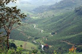
 Lying almost four km from Peerumedu and ½ a km from Kuttikanam, this hill tract, nestled within undulating hills, is spectacular to look at. Gentle breeze offers a stroke of affection to the people. Taking stroll for miles one can see the spectacle of sun setting and rising in the open horizon. It is an experience which everybody can cherish for long.


